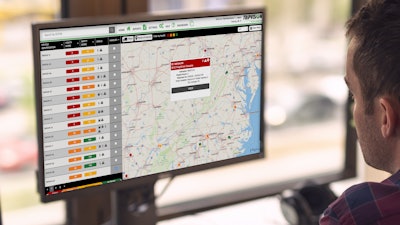
Noregon has released an update to its remote diagnostic application, TripVision, that gives fleets the ability to create geofences. Geofences are location-based tags that inform fleets when an asset has entered or exited a defined area.
Using the new feature, Noregon says fleets can create a geofence at a location and use TripVision’s configurable alerts to learn when a vehicle enters or departs the location. Alerts can be tailored to individual vehicles, vehicle groups, or all assets connected to TripVision. Users can also generate or schedule reports to better understand the total volume of activity at a geofence over a set period, including valuable information such as dwell time within the fences.
“Geofences are yet another example of TripVision’s ability to automate arduous tasks for a fleet,” says Scott Bolt, Noregon’s vice president, product management. “Utilizing geofences removes the need to manually track a vehicle’s location or require a driver to check-in when arriving at a maintenance facility or other location.”
“We put an emphasis on simplifying the user experience whenever we add features to any of our products,” says Bolt. “Creating a geofence in TripVision is an intuitive experience that simply involves drawing a set of boundaries on a map and confirming the coordinates.”